Why does a land-use authority reach across so much of the Salish Sea?
British Columbia describes a Trust Area of about 5,200 km² of land and water. The official map puts broad marine spaces inside local planning boundaries, while ocean approvals remain divided among local, provincial and federal bodies.
One coast. Several legal gates.
- Islands Trust: local planning can zone foreshore, marine uses and structures within its powers. Zoning is not ownership and does not convey provincial Crown seabed. Trust marine program.
- British Columbia and DFO: B.C. administers aquatic Crown land tenure; Fisheries and Oceans Canada administers Pacific aquaculture licences, fisheries and fish-habitat law. B.C. aquatic Crown land · DFO licensing.
- Federal partners: Transport Canada reviews works in navigable waters. DFO, Environment and Climate Change Canada and CFIA share shellfish-sanitation responsibilities. Navigation Protection Program · Canadian Shellfish Sanitation Program.
How this differs from the ALR: there is no single ocean equivalent of the Agricultural Land Commission rule. A federal or provincial permission does not automatically displace valid local zoning. Federal paramountcy applies on an actual conflict or frustration of federal purpose.
The limits of this claim: valid marine zoning can protect habitat and shorelines. This is a jurisdiction and accountability claim—not an allegation that every coastal problem is the Trust's fault.
The map shows the scale.
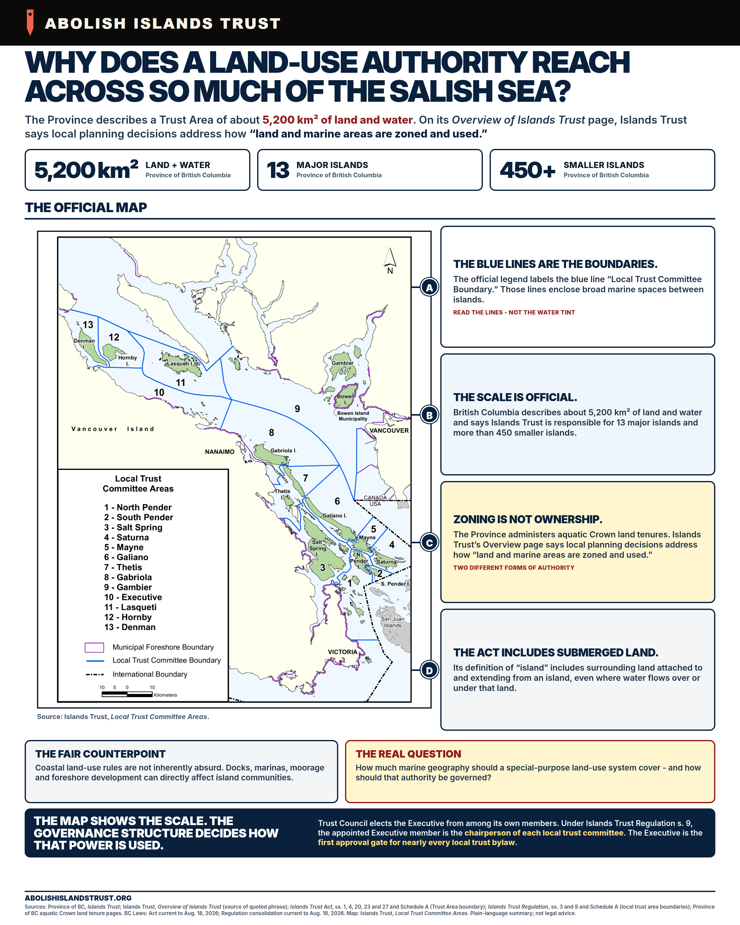
Accessible text edition
- The official scale
- About 5,200 km² of land and water, 13 major islands and more than 450 smaller islands.
- The blue lines are the boundaries
- The official legend calls them Local Trust Committee Boundaries. They enclose broad marine spaces between islands.
- Zoning is not ownership
- The Province administers aquatic Crown land tenure. Islands Trust makes local planning decisions about how land and marine areas are zoned and used.
- The Act includes submerged land
- Its definition of “island” includes surrounding land attached to and extending from an island, even where water flows over or under that land.
The fair counterpoint: docks, marinas, moorage and foreshore development can directly affect island communities. The campaign question: how much marine geography should a special-purpose land-use system cover—and how should that authority be governed?
Define your limits.
The provincial polygons for thirteen administrative areas cover 5,224 km². The bylaws extend marine zoning to those outer boundaries. Our 87.1% figure is only a parcel-residual estimate: it subtracts surveyed parcel land from the polygons, so the residual includes water, roads, and unsurveyed Crown upland. It is not an official water-area total.
1. What they claim: the seabed, the surface, and the air
Not the airspace over their islands — the air above the open sea. 8 local trust areas say it, in two drafting formulas that repeat almost word for word between committees that share no staff report.
- Denman Island — Denman Island Land Use Bylaw No. 186, page 3: “This bylaw applies to the entire area of land, all other islands and islets, rocks, reefs, the seabed, and sea surface plus any other water surface area and all air spaces within that part of the Denman Island Local Trust Area, excepting Indian Reserve Areas, as shown lying within the line designated as the “Zoning Boundary” on Schedule B.” [bylaw]
- Gabriola Island — Gabriola Island Land Use Bylaw No. 177, page 7: “… are adopted as the Land Use Bylaw for Gabriola, Lily, Carlos, Vance, Gaviola, Acorn, Tugboat, Sear, Bath, Saturnina, and Breakwater Islands and all other islands and islets, rocks, reefs, the seabed, and sea surface plus any other water surface area and all air spaces within that part of the Gabriola Island Local Trust Area, excepting Indian Reserve Areas, as shown lying within the line designated as the “Outer boundary of Bylaw 177” on Schedule B.” [bylaw]
- Thetis Island — Thetis Island Land Use Bylaw No. 89, page 3: “This bylaw applies to the entire area of land, all other islands and islets, rocks, reefs, the seabed, and sea surface plus any other water surface area and all air spaces within that part of the Thetis Island Local Trust Area, excepting Indian Reserve Areas, as shown lying within the line designated as the “Area of Bylaw Application” on Schedule B.” [bylaw]
- Mayne Island — Mayne Island Land Use Bylaw No. 146, page 19: “Encompassed in this area of application are the entire land area of all islands, islets, reefs, rocks, and the seabed, and also all surface waters and air spaces.” [bylaw]
- North Pender Island — North Pender Island Land Use Bylaw No. 224, page 18: “Encompassed in this area of application are the entire land area of all islands, islets, reefs, rocks, and the seabed, and also all surface waters and air spaces.” [bylaw]
- South Pender Island — South Pender Island Land Use Bylaw No. 114, page 14: “Encompassed in this area of application are the entire land area of all islands, islets, reefs, rocks, and the seabed, and also all surface waters and air spaces.” [bylaw]
- Lasqueti Island — Lasqueti Island Land Use Bylaw No. 78, page 9: “This Bylaw shall apply to that part of the Lasqueti Island Local Trust Area as shown on Schedule B. Encompassed in this area of application are the entire land area of all islands, islets, reefs, rocks and the seabed, and also the surface waters and air spaces.” [bylaw]
- Ballenas-Winchelsea — Ballenas-Winchelsea Land Use Bylaw No. 28, page 15: “Encompassed in this area of application are the entire land area of all islands, islets, reefs, rocks, the surface and bed of the sea and the water column, and all air space above all such land and water areas.” [bylaw]
2. How far it reaches: to the edge of the trust area
Not a distance from shore. Two bylaws say so outright, in identical words.
- Denman Island (page 10): “Without limiting the foregoing, this includes Denman Island and the areas seaward of its shoreline encompassing all other islands, islets, rocks and reefs, the seabed, and the sea surface, plus any other water surface areas and all air spaces within the boundary shown in Schedule B.”
- Gabriola Island (page 9): “Without limiting the foregoing, this includes Gabriola Island and the areas seaward of its shoreline encompassing all other islands, islets, rocks, reefs, the seabed, and sea surface, plus any other water surface areas and all air spaces within the boundary shown in Schedule B.”
- Thetis Island (page 9): “Without limiting the foregoing, this includes Thetis Island and the areas seaward of its shoreline encompassing all other islands, rocks and reefs, the seabed, and the sea surface, plus any other water surface areas and all air spaces within the boundary shown on Schedule B.”
- Galiano Island, s.4.6 (page 14): “Unless otherwise indicated on Schedule B, marine zones extend from the natural boundary of the sea to the boundary of the Galiano Island Local Trust Area as described in Schedule A to the Islands Trust Regulation B.C. Reg. 119/90.”
- Saturna Island, s.3.2.5 (page 17): “Unless otherwise indicated on Schedule B, marine zones extend from the natural boundary of the sea to the boundary of the Saturna Island Local Trust Area as described in Schedule A to the Islands Trust Regulation B.C. Reg. 119/90.”
- Salt Spring Island, s.9.11 (page 120): “As indicated on Schedule “A”, shoreline zoning covers the entire Salt Spring Island Local Trust Area, with the exception of Piers Island and its surrounding foreshore, and with the exception of the Crown foreshore that lies within 300 m of the natural boundary of Vancouver Island.”
3. Where the controlling boundary is kept
The Trust publishes reference mapping and GIS downloads. The bylaws point to Schedule A of the Islands Trust Regulation, headed “Local Trust Area Boundaries”. Here is Schedule A in its entirety:
“Maps are exempt from publication and may be inspected at the offices of the Ministry of Municipal Affairs, 800 Johnson Street, Victoria, B.C. V8W 9N7, during regular office hours.”
Islands Trust Regulation, B.C. Reg. 119/90, Schedule A — B.C. Reg. 279/99, s. 1. Enabling authority: Islands Trust Act, R.S.B.C. 1996, c. 239, ss. 53 and 54.
What this page does not claim
We do not say the Islands Trust has no authority over water. It has, and the courts have said so more than once. A local government in British Columbia may zone the foreshore and the waters over it, and the two leading authorities are both Islands Trust cases upheld on appeal: Salt Spring Island Local Trust Committee v. B & B Ganges Marina Ltd., 2007 BCSC 892 (affirmed 2008 BCCA 544), about a floating office on a provincially leased water lot in Ganges Harbour, and North Pender Island Trust Committee v. Hunt, 2008 BCSC 391 (affirmed 2009 BCCA 164). We do not say the non-publication is unlawful either. The claim is narrower, and none of that touches it: the legal instruments still point to controlling records in Victoria rather than reproducing them online or plainly reconciling them with the public GIS. In every one of those judgments the fight was over whether a bylaw reached a particular structure. Not one of them cites B.C. Reg. 119/90, and no court has been asked where the outer boundary runs. The full record of what the courts have decided is here, including the occasions the Trust lost.